Sunday, November 20, 2011

Signed, sealed, and delivered

This hitch was the last.  Refuges have been inventoried- no sign left unmarked and no glaring erosion issues overlooked.  Data is ready, well, nearly ready, to be sent to Federal Highways.  And all of us interns are heaving big signs of relief—well, sighs of relief tempered with groans of the soon-to-be unemployed.
Anyhow, this last hitch was titled: Go big! And then go home.  Going big was not a challenge.  Xuan and I landed in Albuquerque, NM and were scheduled to work our way through New Mexico, Texas, Oklahoma, Arkansas, Louisiana, and Mississippi.  This hitch we hit the ground running.  We touched down in Albuquerque and picked up our rental.  Then we went grocery shopping at a lovely food co-op in the city and headed out of town and straight to our first refuge: Sevilleta NWR.  This hitch was all 2.5-ing.  We got a bit ahead in our work schedule so the past few months most crews have been re-visiting refuges to hike all of their trails, not just the ones refuge managers suspected had new additions.  There was only a short trail on Sevilleta and so we were able to get into the town of Truth or Consequences at a decent hour to check in to our fantastic room at Riverbend Hot Springs Inn.  T or C is a hot springs town on the Rio Grande.  It has a cool feel to it- lots of artist galleries, health food shops, and, of course, hot springs. The Riverbend place had rooms in refurbished mobile homes.  It sounds kind of weird, but it was very cool.  And the hot pools on the Rio Grande were sublime.  We felt a bit like we were on a vacation.
We stayed in T or C for a few days while we worked nearby at Bosque del Apache NWR.  
Bosque del Apache NWR

Hiking at Bosque del Apache

We (me and Xuan, my coworker) decided we would work really long days so we could maximize our free time.  So we were able to take a day to go bouldering at Hueco Tanks state park in Texas and had time to explore Santa Fe and Taos.  We got some snow and shivers up at the Taos ski area, some excellent Mexican food near Santa Fe (tableside guacamole service!) and some good snowy walks in Carson National Forest. 
Snowman in Taos
It sparkled

Earthship house outside of Taos

Hueco Tanks State Park... success!
Palo Duro State Park

"The Grand Canyon of Texas"

Unfortunately our time in New Mexico had to end and we headed east into northern Texas.  We stayed the night in Palo Duro State Park or “The Grand Canyon of Texas” and experienced the town of Amarillo, TX.  I will not be back.  
From there we drove and drove until we reached the Wichita Mountains in Oklahoma. .  I wasn’t expecting to like Oklahoma too much, but it was actually a pretty cool place.  I noticed that it seemed like in every small town we passed though all the houses were very neat and well-kept.  Much more so than most towns in the south.  We started at Wichita Mountains NWR, which is a very cool place.  The mountains, well, “mountains” rise up from the flat landscape impressively.  It’s like this: ________/^\/^\/^\______.  Apparently the mountains used to be a playground for the rich and famous.  And they nearly decimated the wild animal population.  This refuge is a success story.  It is now once again home to wild herds of Bison, Elk, and Longhorn.  We met up with one beefy bison on a trail- we gave him plenty of room.  I got to have a longhorn burger thanks to the other employee staying in the bunkhouse.  The bunkhouse itself was interesting- it was cobblestone, the historic style of the area, cobbled of stones collected in the mountains.  When we pulled up there was this giant Bison hide lying out to dry.
Texas
After Wichita Mountains we drove to Oklahoma City for groceries.  While we were there we checked out the climbing gym and ate Vietnamese food in Little Saigon.  Our next stop was Tishmingo NWR.  There was only about a mile of trail to walk, but we spent an extra day there to catch up on data work.  We were also invited to a Partner’s luncheon.  We accepted and spent lunch with about 70 men and about three women… and a lot of tasty southern foods- fried fish donated by the fishermen in the group, hush puppies, French fried potatoes, baked beans, chili, hot dogs, pie, pudding, and other great looking dishes that I couldn’t fit into my stomach.  
Approaching our last week now we drove to Arkansas and spent a few nights at Hot Springs National Park.  we didn’t go into any hot springs (they’re all privatized) but we hiked a bit and went into Little Rock one day.  We worked at Felsenthal NWR in southern AR and then dipped into northern Louisiana for Black Bayou Lake NWR.  Then, even though we put it off as long as possible, we crossed the state line into Mississippi.  We were visiting refuges to re-walk all the trails two guys had covered earlier in the year with a bad Trimble (means possibly inaccurate data).  From what these guys told us, Mississippi was a big muddy mosquito pit.  So we didn’t have high hopes.  But I think we hit it at a better time of year- not so much mud and some rather pretty fall colors.  And only about three mosquitoes. Of course the Mississippi mud that was still there did catch us- we, well, I got the van stuck as we drove one of the ATV trails.  After an hour of fruitlessly jamming branches under the tires in attempts to get some traction we had to text someone at the Boise office and have them call the refuge manager, since the cell phone reception wasn’t good enough for us to get out a call.  The refuge manager arrive about an hour later and pulled us out.  We didn’t drive anymore trails that day.  And Mississippi Mud ice cream with now be a new experience for me.
Stuck in the mud
Cypress trees in Mississippi

Fall colors
Tirelessly working away

The little nook in our room
We spent our last few days at a lovely B&B just south of Jackson.  There we worked tirelessly on cleaning up data and making sure everything is 100% ready to go.
We returned to Boise on Saturday and it felt like we barely unpacked before we had to pack up again and head back to the airport for one final trip.  We spent four days in West Virginia at the National Conservation Training Center meeting refuge folks, making a movie (well, a training-type video), and inventorying their trails in the driving, cold West Virginia rain.  But that’s another story for another time. 
Taking up space in the airport
Back in Boise now.  The job officially ends tomorrow and most people head home on Tuesday.  I’m so ready for this to be over.  What just happened?!  That’s what I’ll be figuring out these coming months.  For now I am happy to be officially renting an apartment in Boise.  Now every day I will put my shoes by the same door and put my head down to sleep on the same bed every night.  It’s going to be great.

Tuesday, October 18, 2011

California and Hawaii

 One night on hitch 7 in Alabama, Tennessee, and Kentucky, I found out I was going to Hawaii the next month.  At the moment I was quite traveled-out, and the thought of flying to California for a week of work, then to Honolulu for a refuge on Oahu, little puddle-jumper to Maui for the second refuge, and one last flight back to Boise… well it sounded like lots of flights.  Also we travel with a small tower of luggage: cooler, two duffels, and two heavy cases of tech gear.  Plus one extra carry-on each.  And while doing it for the last seven eight months has made it all easier-- learning how to walk with a heavy duffel bag strung across your shoulder, a backpack on your back, and a cooler full of camp gear (sometimes balancing a tech kit on top)-- it's surprisingly not impossible.  It just sounds impossible.  Anyhow, we've all come a long way with our travel skills.  But the duffels haven't gotten lighter and the sun hasn't gotten cooler, and a mile is still a mile.  So it continues to be draining.

            Luckily I came to my senses.  I was being set to Hawaii! For work!  I’ve never really given thought to going to Hawaii.  I guess when I think Hawaii I think beaches, beaches... and waterfalls.  I was right about that.   

Before I get to Hawaii though I have a few things to say about Central CA.  Most of the time was not noteworthy, except two amazing In-N-Out dinners.  But we did manage to finish work early and head to Yosemite for a couple nights.  Susan and I split up to do two different hikes- I hiked to Cloud's Rest from Tenaya Lake, and from there down into the valley.  16 miles total. My feet and knees were screaming at me by the end, but it was a beautiful hike.
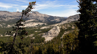
The High Sierra in Yosemite


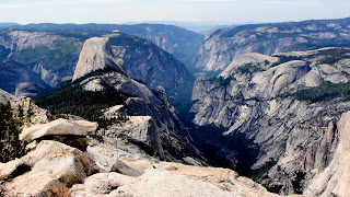
View into Yosemite Valley from Cloud's Rest
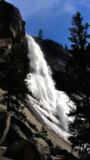
Vernal Falls
We left from Sacramento on Saturday to fly to Honolulu.  After landing in Honolulu we checked into our hotel and walked five minutes to the beach.  I think every day involved the beach in one way or another… plenty of beach-sitting, swimming in the big ocean waves, camping near enough to hear the constant rhythm of the surf, and snorkeling!  I went snorkeling for the first time and got to watch flashy neon fish play hide-and-seek in the coral.  I was even fortunate enough to see a sea turtle swimming around in front of me.
We also had fantastic food: mangos, coconuts, fresh sugar cane to suck on, sushi, Japanese pastries, fish tacos, pina coladas, stir-fry for breakfast, French toast covered with local banana, macadamia nuts, coconut and coconut syrup! 
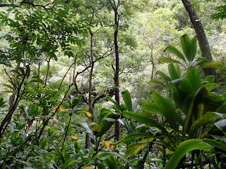
In between beaches and food, we also worked on two refuges: Oahu Forest NWR and Kaelia Pond NWR on Maui.  Oahu Forest had a beautiful and very remote trail in the center of the island where there are dramatic, densely forested ridges and valleys.  The trail took us mostly along a ridgline and we had fantastic views of the island: Pearl Harbor and Honolulu to one side, and deep green hills and valleys to the other.  Kaelia Pond was a  little less enchanting, but we did map a nice coastal boardwalk.
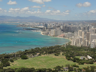
View of Honolulu from Diamond Head Crater


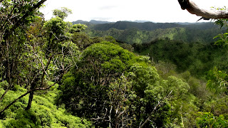
View from hike in Oahu Forest NWR

On Kiapapa Trail in Oahu Forest NWR
 We spent about two and a half days on Oahu.  Explored a bit of Honolulu, hiked up Diamond Head Crater just outside the city.  We left Honolulu fairly quickly in favor of someplace with fewer high-rise hotels.  We spent two nights on the Northshore, the windward coast of the island.  On Wednesday we turned in the rental car and got ourselves and our luggage on the short little island-hopper flight to Maui.  Someone had told me in Hawaii, Oahu is the city, and Maui is the country.  And it was—lots of agriculture in the center, no cities anywhere near the size of Honolulu, two big mountains on either side of the island, and few roads.  Maui was beautiful.  We spent a night in Kihei which is the town where the refuge is located.  We had some delicious sushi on a patio overlooking the ocean and also enjoyed some pool time at the hotel.  We spent two nights camping and exploring Haleakala National Park on the eastern part of the island.  Haleakala is a 10,000 foot mountain with a spectacular view of the sunrise each morning.  I made it up just in time to see the sun rise over the layer of clouds below the mountain summit.  It was pretty incredible.  We spent one night camped high on the mountain, then drove around to the other side on a very narrow and crowded road to Hana.
On Mt Haleakala

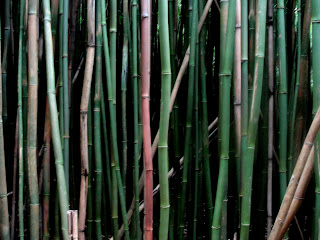
Hiking through a bamboo forest
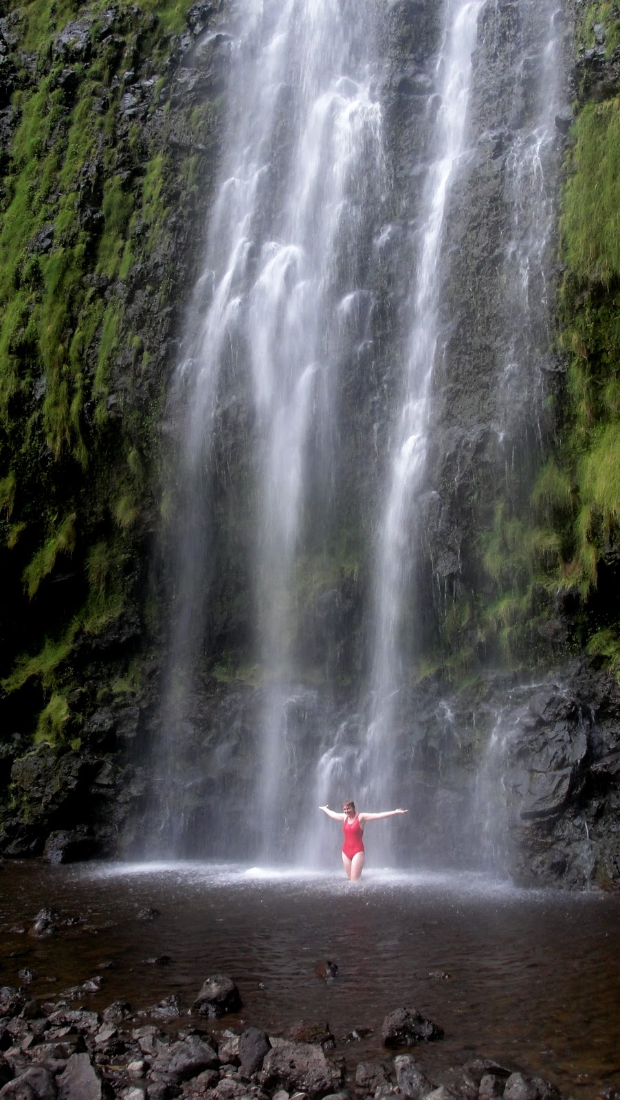
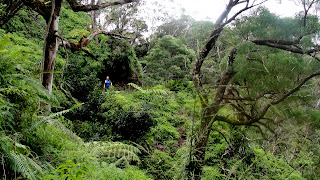
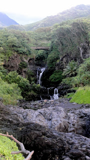
 In the Kipahulu part of the park we hiked to the base a a very tall waterfall and had an idyllic moment standing under streams of refreshing Hawaiian water, on Maui.  (Ahem, all in the name of work.)
Hiking in Maui
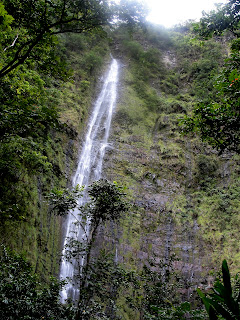
Waterfall in Kipahula portion of Haleakala NP

Waterfall shower!

Waterfall pools

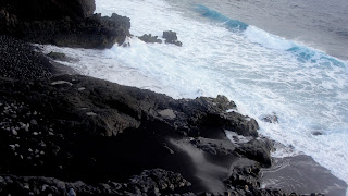
Black sand and blue water
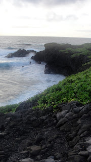
Coast of Maui
We left Maui after having three days to soak it in.  Susan and I were both ready to go home- although there always seems to be a need for just a few more hours on the beach.  And maybe one more plate of sushi. 

My next (and final!) hitch starts on Monday.  I'm flying into New Mexico, then hitting a refuge in northern Texas, moving up and through Oklahoma, to Arkansas, Louisiana, and ending in Mississippi!  It's a lot of ground to cover, but I'm exited for one last crazy hitch.

Monday, August 15, 2011

a few more Oregon/California photos

The Boy Scout Tree

It's always sunny in Oregon

Trail description: From Lighthouse Rd Parking to Pacific Ocean

I'm frightened because...

our van looks like this. ... camping jambalaya.


Mount Adams


Do you ever get the itchy urge to do something extreme?  I do.  I get this drive to do something that kicks my butt and, at the time of doing, tends to be a miserable sufferfest.  But when all is said and done I can just feel totally, unselfishly awesome.  And I can think back on the glory days as I sit at a desk in Boise click-clicking on hundreds of squiggly trails I did not walk with features I never saw. 

Last weekend four of us planned an excursion to Washington to climb up Mt. Adams.  Last year I did trailwork on the PCT at the foot of Adams.  The mountain was our constant backdrop during work and in camp.  At night the full moon lit up the glaciers to ignite an alpine glow.  The idea of climbing up the mountain was intimidating and awesome.  Adams rises like a beast out of a rather subtle landscape in southern WA, giant, snow-covered, and 12,276 ft tall.  We drove to Washington on Friday and arrived after dark.  In the morning we could see Adams looming through the trees in our campsite.  We quickly ate breakfast and packed our bags and started on our way to hike the mountain.

“You and 220 others.”  The forest service lady was quite frank with us as she filled us in on the essentials: Drive slow to the trailhead, the road is single-lane most of the time and people drive too fast around blind curves.  Do not descend to the southwest, you will get hopelessly lost in trees.  Melting snow is the only way to get water at the lunch counter (base camp).  You share camp with hundred of others, some who do not dispose of their waste properly, so boil your water to avoid contracting an exotic disease.  Here are your WAG bags.  Use them.  Do not glissade with your crampons on, you will break a leg.  Be careful of cornices or you will find yourself taking the very quick way to the bottom.  She was lovely.  Once we had our permits and our map we drove that crazy mountain road to the trailhead.

Our boots hit the trail by 10:30.  It was pretty rough from that moment on.  The unfortunate thing about climbing up a mountain is that… it’s all up.  There is really no relief.  So we went up.  Up into the snow that relentlessly reflected the sun so our skin was exposed in every possible place.  The underside of my nose has never been so abused.  When we felt like we were nearing Lunch Counter (our base camp for the night) we started asking people on their way down about how far we were…. the first guy said 800 feet.  About 20 minutes on, the second guy said 900 feet.  The third guy, a bit further on, told us 1,000 feet. These were not comforting predictions.  At that point I just put my head down and walked.  We made it to Lunch Counter at about 3 pm.

UP!

View of Mt Hood from our tent


Mountain shadow
Melting snow for water
We found a cozy place to set up tents.  There are lots of rock wind-barriers set up, so we snagged a few of those and when the tents were up we climbed in a laid down flat for a good while with our boots off.  Too soon we had to get up and start the process of melting snow for drinking water the next day.  It took forever. 


We went to bed with the sun because we planned to get up at 3 am to continue to the top.  Unfortunately at 3 am the wind was howling and the tents were flapping like mad tethered birds trying to take flight.  It was not the sort of morning that gets you out of your sleeping bag easily.  So we reconsidered.  Set the alarm for 5 and tried to keep sleeping despite the racket.  At 5 nothing much had changed, but after peeking out the tent and seeing clear blue skies we decided we better get a move on.  We got some coffee and food in our bellies and got all decked out in gaiters, crampons, ice axes, hats and gloves, and sunglasses.   


The morning was just one step at a time.  I was just reciting to myself, “step.  step.  ice axe.” repeat.  It was a good rhythm.  Right before we got to the false summit (the think that looks like the top of the mountain, till you get there and realize the top of the mountain is still a good ways off) we were surrounded by swirling cloud wisps.  
clouds found us


Nothing too bad, but we couldn’t see too much in our immediate surroundings.  And we definitely could not see the view or the real summit.  But we’d come so far, so further we went!  To the summit!  We made it around 11 am.  It was very cold and very windy.  No view to speak of.  But it was exhilarating.  We took some pictures and ate a nearly frozen pb&j and then scurried back down to warmth and sunshine. 
Toji, Dave, Me, and Christina on top of a mountain

weeee! and now I'm ready to return to the safe life I remember at 2,000 feet
The decent was more of an amusement park ride.  There was a glissade chute that took you down about 2000 feet from the false summit back to lunch counter.  You just sit your butt down in the chute, position your ice axe for braking, and ZOOM.  You fly down that hill. 

Our trip ended with a beer and a burger in Hood River and a seven hour drive with 5 people, 5 packs, and plenty of miscellaneous gear in a tiny Honda civic.  We got back into Boise at 4 am.  It was great.  I plan on climbing more mountains as soon as possible.


Wednesday, August 3, 2011

Or-y-gon, Californ-i-ya, and Idy-ho!


This July I was sent to inventory trails in Oregon, with a little dip into northern California for a few refuges on the border, and one refuge in Idaho before we landed at home.  Being that this hitch was relatively close to Idaho, Toji and I didn’t have to book flights anywhere and instead just picked up our rental minivan in the morning, packed it full of our bags of things and cases of technology, a stove, tents, a cooler of food and a box of dry goods, our bikes, and the four-foot level.  It was a full load, and despite both of our tendencies to be rather disorganized, we didn’t lose anything.  With the doors slammed closed we took to the road and drove to our first refuge, Malheur NWR, in eastern Oregon.  The high, hot desert.  We camped about in the middle of the 40-mile long refuge and got to see one of those clear desert sunsets and moon-rises.

            Between Malheur and the CA refuges we drove through Bend, OR for an important Deschutes brewery tour.  We spent one night in Deschutes National Forest cozied up with mosquitoes and hit Crater Lake NP in the morning.  We only had time for one hike.  The park had lots of snow still, and we couldn’t get to the top of the hike we were doing, but we managed to get up to the rim by making our own path through the snow.  It is beautiful.
Toji at Crater Lake

            The first three refuges (Malhuer in Oregon and Tule Lake and Lower Klamath in California) were all hot and dry.  While we worked at Tule Lake and Lower Klamath we got to stay in Lava Beds National Monument.  Once we set up our camp we pulled our bikes out of the van and rode around to see some caves.  Lava Beds has all these lava tubes that are totally undeveloped besides a staircase down into them.  Once you get down there it gets very dark, very cold, and very quiet.  There are lots of passage ways off the main route that make you think about what it would be like to get lost in that dark, cold silence.  We turned off our headlamps and sat quietly until my mind started to wander into thoughts I didn’t want to have down there.  So we flipped our lights back on and felt a little better, but turned around anyway.  One that we went into was called Gold Dome and the walls and ceiling were covered with this wet gold/silvery fungus that sparkled like a room with gold-flecked walls. 
Skull Cave is giant
We stayed in Lava Beds for a couple nights and then drove to Redwoods National Park for the weekend.  Both times I’ve been to Redwoods I’ve been coming out of the desert, and that makes me appreciate all the green, moist forest even more.  We took a few hikes, craning our necks to see the tops of those giant trees.  We sort of accidentally ended up hiking from the 101 all the way down to the ocean.  So much downhill… the entire time all I could think was so much uphill.  But it was worth it.  We popped out right on the Pacific.  And the uphill wasn’t even that bad.


Following our weekend we had work at three refuges on the Oregon coast and one outside of Corvallis.  William L. Finley NWR was outside of Corvallis in the Williamette River Valley and had lots of work.  We stayed there for a few nights in a trailer.  The refuge was beautiful and the trails were actually trails!  There was also poison oak everywhere but we so far seem to have escaped untouched.  Our contact at the refuge was very friendly and ended up interviewing us for the refuge newsletter.

We spent our second weekend in Portland staying with Toji’s cousin.  We ended up pitching our tent in his backyard for a few reasons, but maybe mostly because his cousin is in a rock band and it was just better/quieter in the yard.  We went and saw his band play a show—they’re called Raremonk.  Look them up if you like rock.  We did lots of biking around the city.  I got to drink cup after cup of great coffee and go to Powells bookstore twice.  We bought raspberries and breakfast burritos at the farmers market.  And I caught up with one of my friends for a while.  It was a good time, although there was lots of rain.  Portland is a great city, but I was not really in a city mood, so when we drove out to the coast on Monday it was a relief. 

Our last coastal refuges were pretty ideal.  One trail led to a giant Sitka spruce, one led to the ocean shore, and the other ones all ended at nice scenic overlooks.  We visited the Tillamook cheese factory… it was on the way, twice.  We watched hundreds of giant blocks of cheese be cut down to baby loafs and wrapped up in their packaging.  Then we sampled all the cheese and then since the sample line shot us right out into the ice cream line, we had ice cream as well.  It was great.  Also an alarming display of fat Americans in bad dress eating cubes of cheese and over-sized ice cream cones.  Sorry to be brutal; just reporting what I saw.

            We finished all of our scheduled work a bit early so we rather leisurely made our way back to Idaho.  We drove through the Columbia River Gorge and stopped at Maltnomah Falls.  We stayed near Hood River for a night and did a big hike in the gorge before driving further toward Idaho.  We ended our hitch at Deer Flat NWR in Nampa, ID.  Only 45 minutes from home. 
Overlooking the Columbia River Gorge from Dog Mountain

            It was a grand tour of Oregon.  Being home has never felt quite so good as it does now.  Fortunately I am a Boise office peon next hitch, meaning I get to sleep in the same bed every night.  At the cost of staring at the same computer screen every day.  But I am willing.  It’s HOT in Boise.  But we have our ways… on Wednesday we left work a bit early to float the Boise river.  We rented four tubes and two rafts and jumped in the cool, cool river.  Then you just relax and try to not hit trees on the riverside as you float to the takeout about an hour and a half downriver.  There seems to be hundreds of people floating the river everyday here… it’s a fantastic way to escape the heat.

            This weekend we’ll trade Boise heat for Washington snow.  Five of us are going to attempt to stand on top of Mount Adams… 12,500 ft up in the sky. 

            I’ll try to write another post while I’m in Boise.  My days will be filled with linear referencing, the oddly satisfying but totally intangible job of measuring the distance of each feature point we take from its respective trailhead.  And cleaning up the massive mess of data we have created for ourselves.  When my mind becomes too boggled by little numbers that are supposed to match little lines and little dots on my computer screen, I will find relief in writing a little update.